The NEMESIS project receives funding from the European Union through the 'Horizon Europe' program. Algerian researchers participating in this initiative utilize satellite technology to track environmental changes across the country. The project monitors vegetation cover, drought, and desertification. The research team measures water and wind erosion to assess land degradation. By employing these data sets, scientists intend to provide accurate information regarding the state of the terrain. The program integrates these findings to support environmental management efforts in Algeria. The NEMESIS project is funded by the European Union under the 'Horizon Europe' program, providing the necessary resources for this extensive environmental study.
Satellite Technology for Environmental Monitoring
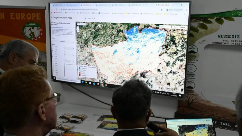
Researchers utilize satellite imagery and remote sensing techniques through the 'Google Earth Engine' platform to process environmental data. This digital infrastructure allows the team to analyze landscape shifts by integrating high-resolution spectral information gathered from space-based sensors. The project utilizes satellite imagery and remote sensing techniques via the 'Google Earth Engine' platform to ensure that the data processing remains efficient and scientifically rigorous. This technological framework is essential for handling the large volumes of information required to track environmental shifts across the vast Algerian landscape.
The digital application currently under development provides a monthly database spanning 25 years. This temporal depth enables scientists to identify long-term patterns in vegetation loss and soil transformation across the Algerian territory. By maintaining this chronological record, the system tracks specific ecological markers that indicate the progression of desertification over the quarter-century period. The digital application being developed provides a monthly database spanning 25 years, ensuring that the research team has access to a full historical perspective on land changes.
The project aims to monitor vegetation cover, drought, desertification, and water and wind erosion. By focusing on these four specific indicators, the NEMESIS project seeks to create a holistic view of the ecological challenges facing the region. The data collected regarding these factors allows for a detailed assessment of how environmental conditions have evolved over the 25-year period covered by the database.
The University of 8 May 1945 in Guelma is participating in the project. Academic staff at the institution contribute to the analysis of the collected datasets, applying local expertise to the interpretation of the satellite-derived information. This collaboration integrates the technical capabilities of the 'Google Earth Engine' platform with the research output of the University of 8 May 1945 in Guelma to refine the accuracy of the environmental monitoring tools. By leveraging the academic strength of the University of 8 May 1945 in Guelma, the project ensures that the satellite imagery is analyzed within the specific context of the local terrain and regional environmental conditions. This partnership remains a cornerstone of the NEMESIS project as it continues to refine its monitoring capabilities.